skysurvey#
skysurvey is a python package made to simulate astronomical targets as they would be observed by a survey.
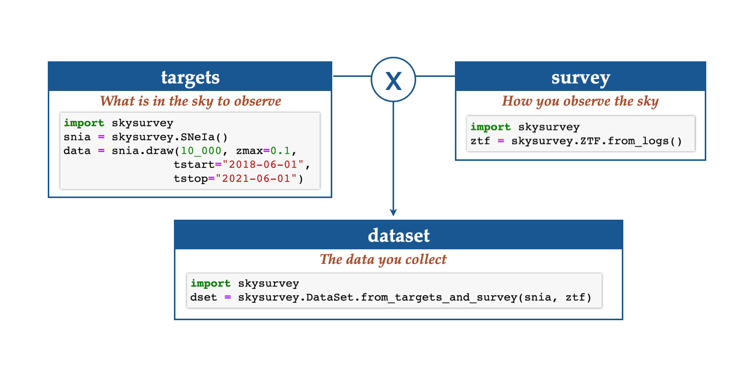
To simulate a realistic lightcurves you need two things:
target properties as given by nature.
survey observing data providing what has been observed when and under which condition.
Joining these to create:
a dataset, i.e. simulated data of the targets observed by your survey.
Elements#
Survey objects handle your observations. It can
match sky positions with observing logs and provide observing
statistics. There are two kinds of
surveys: Survey that accept any observing pattern and
GridSurvey that are customed for field-based surveys.
DataSet corresponds the actual data you would have collected
observing target (s) with your survey. A dataset is easy
and fast to load, and it contains analytical and visualisation tools.
Sharp start#
You need to create a Transient object, a Survey object and then to simulate how your survey would observe your targets. This latter is called a DataSet.
Step 1: transients#
Draw the ‘truth’
import skysurvey
snia = skysurvey.SNeIa()
data = snia.draw(size=50_000, inplace=True) # inplace sets snia.data
data.head(5) # see also snia.data
import skysurvey
snii = skysurvey.SNII()
data = snii.draw(size=50_000, inplace=True) # inplace sets snia.data
data.head(5) # see also self.data
import skysurvey
# genetic time serie transient
# specify the template (e.g. from sncosmo) and the absolute mag (loc, scale)
# see https://sncosmo.readthedocs.io/en/stable/source-list.html
snib = skysurvey.TSTransient("v19-2005bf-corr", magabs=[-18, 1])
snib.draw(50_000, inplace=True) # inplace sets snia.data
snib.data.head(5) # also self.data
You have more built-in targets. You can also directly use target = Target.from_draw().
Step 2: survey#
Provide what has been observed when
import skysurvey

# footprint
from shapely import geometry
footprint = geometry.Point(0,0).buffer(2)

# observing logs
import numpy as np
from skysurvey.tools import utils
size = 10_000

data = {}
data["gain"] = 1
data["zp"] = 30
data["skynoise"] = np.random.normal(size=size, loc=200, scale=20)
data["mjd"] = np.random.uniform(56_000, 56_200, size=size)
data["band"] = np.random.choice(["desg","desr","desi"], size=size)

data["ra"], data["dec"] = utils.random_radec(size=size,
                                             ra_range=[200,250],
                                             dec_range=[-20,10])

# Load a GridSurvey
survey = skysurvey.Survey.from_pointings(data, footprint=footprint)
import skysurvey

# footprint
from shapely import geometry
footprint = geometry.Point(0,0).buffer(2)

# fields
import numpy as np
radec = {'C1': {'dec': -27.11161, 'ra': 54.274292+180},
         'C2': {'dec': -29.08839, 'ra': 54.274292+180},
         'C3': {'dec': -28.10000, 'ra': 52.648417+180}
         }

# observing logs
size = 10_000

data = {}
data["gain"] = 1
data["zp"] = 30
data["skynoise"] = np.random.normal(size=size, loc=200, scale=20)
data["mjd"] = np.random.uniform(56_000, 56_200, size=size)
data["band"] = np.random.choice(["desg","desr","desi"], size=size)

data["fieldid"] = np.random.choice(list(radec.keys()), size=size)

# Load a GridSurvey
survey = skysurvey.GridSurvey.from_pointings(data, radec,
                                             footprint=footprint)
import skysurvey

survey = skysurvey.ZTF.from_logs()
import skysurvey
# lsst opsim files are large, this may take a few minutes (see options)
opsim_path = "baseline_v3.3_10yrs.db" # provide fullpath
survey = skysurvey.LSST.from_opsim(opsim_path)
Survey uses healpy as backend to match position with observing
history, while GridSurvey uses shapely and geopandas. Yet, both
can be used equally in any skysurvey input ;
especially for DataSet.
There are several surveys already implemented, such as ZTF and DES
(shallow and deep fields).
Step 3: dataset#
and get lightcurve data
As you would observe them i.e., the dataset. The simulated lightcurves are in dset.data, the input survey is stored in dset.survey, the input targets is stored in dset.targets.
import skysurvey
dset = skysurvey.DataSet.from_targets_and_survey(snia, survey)
dset.data
import skysurvey
dset = skysurvey.DataSet.from_targets_and_survey(snia, survey,
                                                 incl_error=False)
dset.data
import skysurvey
# simply pass a list of targets
dset = skysurvey.DataSet.from_targets_and_survey([snia, snii], survey)
dset.data
Tutorials#
How to
- Install skysurvey
- Basic usage
- How to
- Use
.draw()and.from_draw() - Load the LSST survey
- Change the rate of a target
- Add Milky-Way extinction
- Create a new
Transientclass - Add gaussian noise to a
Target - Connect surveys with (target) coordinates
- Simulate targets for a specific sky area (and get expected rates)
- Update/change an existing target
- Create a black body Transient
- Use
- Advanced modeling
- Analysis examples
- List of transient classes
API documentation