Connect surveys with (target) coordinates#
Surveys provide methods to associate fieldid with input coordinates.
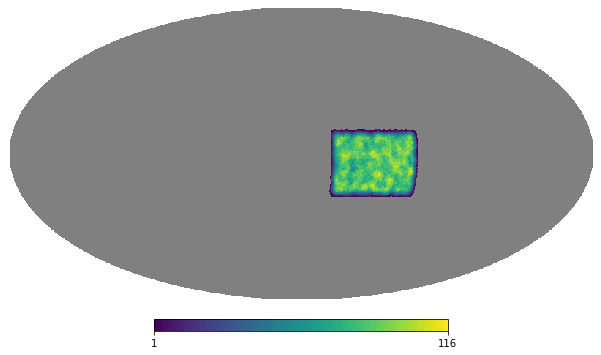
Get a mock Survey#
from skysurvey import example
mocksurvey = example.get_mocksurvey()
mocksurvey.show()
Simulate random SNeIa in the sky#
Let’s simulate 200_000 targets all across the sky
from skysurvey import tools
radec = tools.random_radec(200_000)
.radec_to_fieldid()#
(grid)survey.radec_to_fieldid() enables to quickly associate given coordinates (RA,Dec ; in degree) to given fields.
Associate them with the survey field system#
Have a radec_to_fieldid() method that will
%%time
df = mocksurvey.radec_to_fieldid(radec)
df.head()
CPU times: user 15.4 ms, sys: 5.5 ms, total: 20.9 ms
Wall time: 26.7 ms
| fieldid | |
|---|---|
| index_radec | |
| 0 | 471923 |
| 1 | 473583 |
| 2 | 172259 |
| 3 | 474224 |
| 4 | 8597 |
index_radecis the indice of the input radec targetfieldidis the field index
It takes ~20ms to match 200_000 coordinates over 480 000 fields… (healpix)
and see how it looks
ntarget_per_fieldid = df.groupby("fieldid").size()
mocksurvey.show(data=ntarget_per_fieldid)
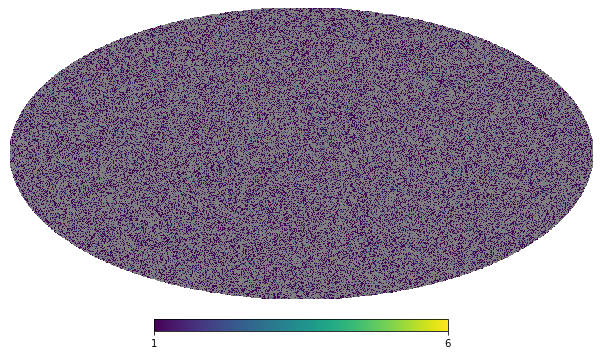
Here the full sky is covered as we did not specify we only want the field actually observed.
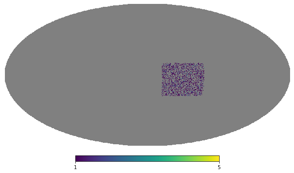
Limit this to actually observed fields#
df = mocksurvey.radec_to_fieldid(radec, observed_fields=True)
ntarget_per_fieldid = df.groupby("fieldid").size()
mocksurvey.show(data=ntarget_per_fieldid)
.get_observations_from_coords()#
If you want to know the observation history of a specific coordinate, simply use the .get_observations_from_coords() method:
mocksurvey.get_observations_from_coords([210, 0])
| ra | dec | gain | zp | skynoise | mjd | band | fieldid_survey | fieldid | |
|---|---|---|---|---|---|---|---|---|---|
| 494109 | 209.444733 | 1.155480 | 1 | 30 | 184.322281 | 58923.765625 | desg | 874 | 240333 |
| 494110 | 210.912842 | -0.473495 | 1 | 30 | 184.363663 | 58925.347656 | desg | 7601 | 240333 |
| 494111 | 208.598297 | 0.043441 | 1 | 30 | 207.956436 | 58911.136719 | desi | 9698 | 240333 |
| 494112 | 208.108414 | -0.253666 | 1 | 30 | 228.037170 | 58926.125000 | desi | 1899 | 240333 |
| 494113 | 211.529388 | -1.009904 | 1 | 30 | 214.324203 | 58913.121094 | desg | 8665 | 240333 |
| ... | ... | ... | ... | ... | ... | ... | ... | ... | ... |
| 494205 | 211.227097 | 0.527715 | 1 | 30 | 189.745224 | 58904.859375 | desg | 1499 | 240333 |
| 494206 | 209.429901 | 0.158741 | 1 | 30 | 198.601501 | 58920.218750 | desr | 5578 | 240333 |
| 494207 | 208.243423 | -0.214293 | 1 | 30 | 231.300903 | 58920.800781 | desr | 6981 | 240333 |
| 494208 | 210.473022 | -1.548322 | 1 | 30 | 197.024139 | 58916.355469 | desg | 8840 | 240333 |
| 494209 | 209.552567 | -1.526825 | 1 | 30 | 190.873367 | 58922.761719 | desr | 6497 | 240333 |
101 rows × 9 columns